Figures made for walking, best seen from the sky.
A desert people of farmers, potters and weavers who scraped giant figures into the pampa more than two thousand years ago. Here is who they were, what they made, and what we still don't know.
Who were the Nasca?
The Nasca lived on the southern desert coast and western Andean slopes of Peru between about 200 BC and AD 650, in one of the driest regions on Earth.1 They grew out of the earlier Paracas culture of the Pisco and Ica valleys, about 200 km to the north; genetic studies suggest the two were the same people, and they shared a belief that water came from the ancestors.1
Water ruled everything. Cahuachi, a large ceremonial center that peaked around AD 50–300, sat where highland water reached the coast and tied the two worlds together.1 The Nasca are best known today for their polychrome pottery and textiles, painted with mythical beings, animals and plants.1 Music mattered too: in 1995 Giuseppe Orefici's team found 27 ceramic panpipes at Cahuachi, apparently broken on purpose as offerings.1
From around 100 BC the climate grew drier. Desertification, deforestation and rising conflict, visible in more warrior imagery late in the period, likely pushed people to higher ground and helped bring the culture to an end.1
Drawn by taking stones away
The figures were made by removing the dark, oxidized stones on the desert surface to expose the lighter ground beneath. The dry, stable climate has preserved them for two millennia.1 Hundreds of straight lines, triangles, trapezoids and spirals share the pampa with animals and plants.2
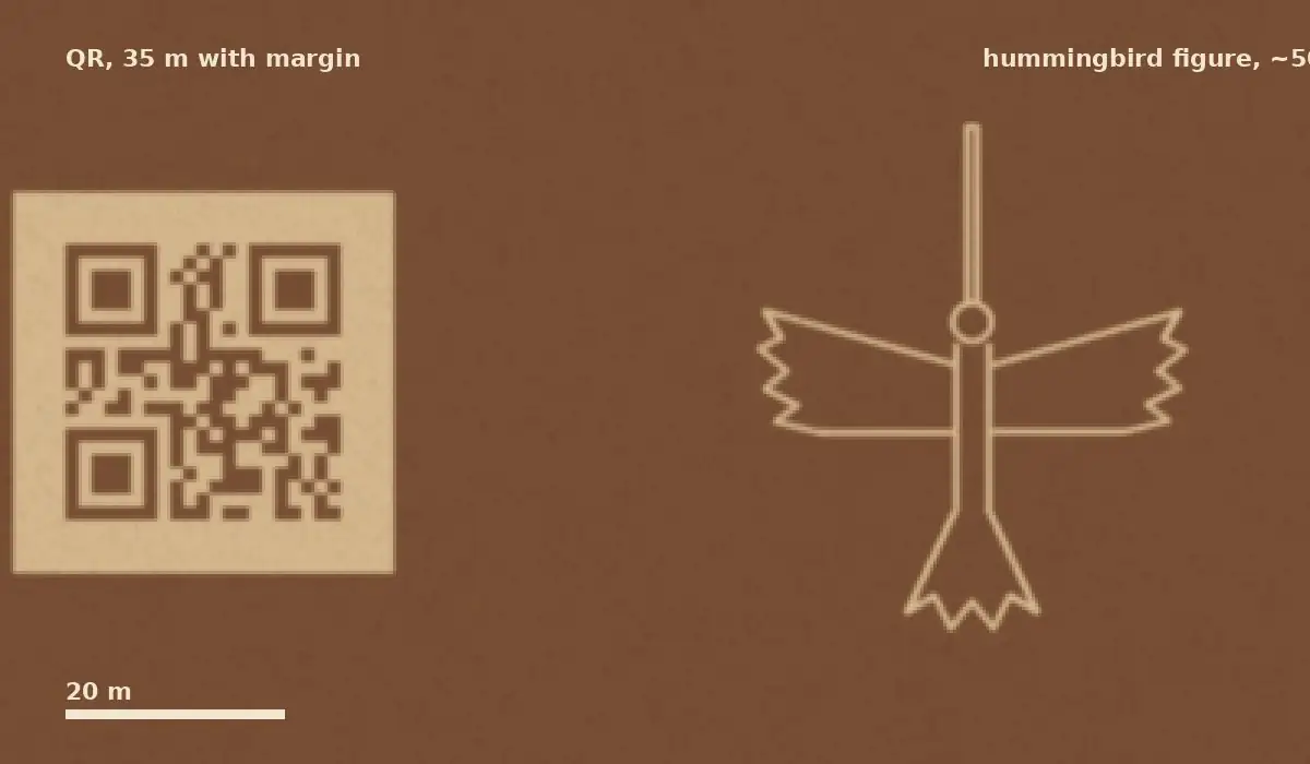
Pelican 285 m. Figure lengths from Britannica;2 other sources give larger sizes for some figures (the hummingbird is often quoted near 93 m). The QR row is our estimate, explained below.
Why make them?
A sky calendar. Paul Kosok saw the lines from a plane in 1941 and proposed an astronomical purpose. María Reiche, who spent decades studying and protecting the site, argued it was a vast calendar.2
Not the stars after all. In 1967 Gerald Hawkins found no correlation between the designs and the movement of celestial bodies.2
Paths for walking. The Nasca-Palpa Project (from 1997) found platforms at the ends of many figures and shell offerings tied to water rituals. Compacted soil, broken ceramics and offerings suggest people walked the lines in groups, with music and dance.12
Small signs along the way. A 2024 survey by Yamagata University with IBM Research used AI on aerial images and found 303 new figurative geoglyphs, nearly doubling the known total. Many are small "relief-type" figures beside ancient footpaths, possibly markers for people traveling on foot.34
Fragile as a footprint
What survived two thousand years can be erased in an afternoon. In 2014, activists walked onto the site to lay cloth letters beside the hummingbird and left marks that drew worldwide criticism.56 In 2018 a truck driver ignored warning signs and left deep tire marks over an area of about 50 × 100 m, damaging three geoglyphs.6
The lines are best seen from the air, with licensed operators, and never by stepping onto the pampa.
A code you could read from orbit
The Nasca made images whose full shape only shows from high above. A QR code works the same way: it only makes sense to a camera. How big would one need to be for a satellite photo to scan?
The smallest QR (21 × 21 squares, plus a 4-square margin on each side) needs about 4 image pixels per square to decode reliably. Today's best commercial satellites capture about 30 cm per pixel,7 so each square needs to be about 1.2 m: a code roughly 25 m wide, 35 m with its margin. Smaller than the hummingbird. At the 10 cm per pixel newer satellites are aiming for, it shrinks to about 12 m.8 Our simulated 30 cm image below decodes to miqr.us.

We would never build anything on or near the Nasca pampa. A real "read from space" code would go on private land with permission, such as a farm field or a rooftop.
Print this page's code

This code opens this page: wiki.miqr.us/NAZCA. You're welcome to print it on a poster, a class handout or a travel guide. No sign-up, no cost.

The red heart in the corner is miQR's mark. Every miQR code carries one.
Sponsors of this page
This page has no sponsors yet. Sponsors help keep the miQR Wiki open to everyone at no cost, and are listed here with a link.
Want to sponsor this page? Write to hello@miqr.us.
Sources
- Who were the Nasca? British Museum
- Nazca Lines Encyclopaedia Britannica
- AI-accelerated Nazca survey nearly doubles the number of known figurative geoglyphs PNAS, 2024
- Over 300 geoglyphs discovered in the Nazca Pampa using AI HeritageDaily, 2024
- Greenpeace and the Nazca Lines National Geographic, 2014
- A truck just plowed into the 2,000-year-old Nazca Lines ScienceAlert, 2018
- First images from WorldView Legion Maxar
- Albedo takes Earth observation up close TechCrunch, 2024
- Lines and Geoglyphs of Nasca and Palpa UNESCO World Heritage Centre